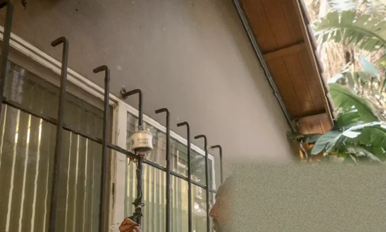
In Pacoima, a densely packed neighbourhood in Los Angeles’s north-east San Fernando valley, residents are deploying shoebox-sized sensors to monitor the air they breathe. The white containers, known as Aeroqual stations, are part of a community-driven programme run by the local environmental group Pacoima Beautiful. On a recent March day, environmental project manager Shance Taylor climbed a ladder to fix one of the devices to the side of Jose Luis Salas’s house, connecting it to the homeowner’s wireless internet before zip-tying the box to the white siding. The sensor is one of six placed on business rooftops, playgrounds and homes across Pacoima, designed to capture real-time measurements of pollutants including PM2.5 and ozone.
The monitoring programme, which began in 2019, uses several types of sensors to attack the problem in different ways. Alongside the six Aeroqual stations – supplied in 2025 by the regional state agency South Coast Air Quality Management District – the group has installed commercially available Purple Air monitors on community buildings and residents’ houses. Between 2020 and 2025, Pacoima Beautiful also ran a six-week programme each summer called Air Ambassadors, in which citizens clipped palm-sized white AirBeam monitors to their backpacks or waistbands and walked around the neighbourhood. These devices take a snapshot of air quality every few minutes and log it with the location, producing a real-time map of personal pollution exposure. Amanda Ortega, a teacher in the Los Angeles Unified School District, took part in the summer of 2025 and said the highest levels of pollution she recorded were in lower-income neighbourhoods. One spot off San Fernando Road near the freeway stopped her in her tracks. “I thought: Whoa. This is bad,” she said.
The Aeroqual sensors use active fan sampling technology and can measure PM2.5, PM10, ozone, nitrogen dioxide, temperature and humidity. The data is transmitted to a dashboard where it can be monitored. Pacoima Beautiful carefully studied where to install the stations, and the results already show that air quality in Pacoima is routinely worse than in nearby neighbourhoods. A week after the sensor was installed at Salas’s house, the amount of microscopic airborne particles – PM2.5 – was higher than at reference stations in nearby Reseda or North Hollywood, even though the overall air quality was rated moderate.
Why Pacoima stands out even in polluted Los Angeles
Los Angeles is rated one of the worst cities in the United States for air pollution, but Pacoima faces an exceptional burden. The working-class, multicultural community of more than 81,000 people is squeezed into just seven square miles, making it one of the most densely populated areas in Los Angeles county. It is hemmed in by three major freeways – Interstate 5, Highway 118 and Interstate 210 – and also hosts a small regional airport, Whiteman Airport, which has operated since 1946 and uses lead-based aviation fuel. According to the California Environmental Protection Agency, Pacoima is one of the state’s most environmentally burdened communities because of its proximity to freeways and heavy industry that pump out pollution. The neighbourhood is a natural flood basin surrounded by mountains that trap smog, diesel particulates and other pollutants, creating what residents and researchers describe as a “basin of toxicity”.
More than 500 cargo trucks roll through the narrow streets each day, along with over 100,000 cars on each freeway. In 2023, students from California State University, Northridge, led by urban planning professor Paloma Giottonini, tallied more than 200 trucks in the first two and a half hours of a single day. Over 300 industrial sites – including auto-dismantlers, landfills, factories and recycling centres – contribute to air, soil and water pollution. An older fossil-fuel power plant, Valley Generating Station, also adds to the problem. The placement of freeways and industrial facilities in Pacoima has historically been a racialised issue, intended to divert pollution away from more affluent neighbourhoods.
The health consequences are stark. Nearly 9% of residents have asthma, one of the highest rates in California. Respiratory disease, cardiovascular disease, low birth weight and premature births are also elevated. Children and the elderly are particularly vulnerable. Jose Luis Salas, who has lived in Pacoima for 26 years, said there are days when no fog or breeze is present but smoke can still be seen in the streets. Sometimes when he exercises outdoors he struggles to breathe. “They are impacted by every possible thing in Los Angeles,” said Giottonini. “They’re surrounded by freeways. They’re surrounded by factories, landfills, power generation, so all the pollution is there.”
Community-led efforts to fight back
Pacoima Beautiful was founded in 1996 by five mothers concerned about the trash and toxic smells their children faced walking to school. It is the only environmental justice organisation in the north-east San Fernando valley. Over the years it has expanded far beyond litter, taking on projects that address the climate crisis and pollution. The group has worked with the city to cover more than 700,000 square feet of roads, school playgrounds and parking lots with a reflective, light-coloured epoxy coating – known as cool pavement – that aims to lower surface temperatures. A 2020 study published in Environmental Research Letters found that such coatings decreased pavement temperatures by up to 10 degrees Fahrenheit in two Los Angeles neighbourhoods. Pacoima Beautiful also helped create a sidewalk garden where residents plant free edible fruits and vegetables on a site once plagued by illegal dumping.
One of the group’s biggest current projects is the air quality monitoring network. The hyperlocal data is critical because the closest official regulatory monitor used by the US Environmental Protection Agency is miles away and does not reflect conditions on the ground. As Giottonini explained, “They can come to the city saying: ‘Look at our levels. Our levels are much higher than everywhere else. Do something about it.’ Data in the hands of the community is really powerful.” Pacoima Beautiful is advocating for more Air Quality Index (AQI) sensors across the entire north-east San Fernando valley.
The group is also running a campaign to shut down Whiteman Airport, citing concerns about emissions from leaded aviation fuel, noise pollution and safety risks – including multiple aircraft accidents near the airport, some of them fatal. The EPA has concluded that lead emissions from aircraft pose a risk to public health. Pacoima Beautiful offers environmental education programmes in local schools, including the “Agua University” initiative that engages youth in sustainability, and its “Clean Air Ambassadors” programme, supported by a Transformative Climate Communities grant, aims to empower residents on environmental justice issues. The organisation has also participated in California Environmental Protection Agency initiatives that target pollution in disadvantaged communities.
Broader implications of community air monitoring
The value of low-cost sensors extends far beyond Pacoima. In Sonoma county, when wildfires swept across the region in 2020, researchers led by Michael Mendez, a professor at the University of California, Irvine, who grew up in Pacoima, wanted to understand the risks to farmworkers. They compared data from a single official AirNow monitor – the EPA’s official air quality reporting system – with 359 monitors from PurpleAir. The PurpleAir data showed that nighttime air quality during the fires was sometimes worse than daytime, contradicting misinformation that it was safer to work in the fields at night. Two large wineries, E&J Gallo Winery and Eco Terrano Vineyards, have since guaranteed their employees and contractors hazard pay whenever air quality from wildfire smoke is deemed unhealthy for the general population. Mendez noted that even California, often seen as an air quality leader, has an “antiquated” AirNow system that focuses on precursors of smog and PM2.5 but does not measure heavy metals or volatile organic compounds that become common after fires.
In Washington state’s Methow valley, steep geography traps pollution near the bottom, and the area suffers from nearby seasonal wildfires. Liz Walker, a professor at the University of Washington who runs a consulting business on air quality, helped create a PurpleAir sensor network that became one of the largest rural networks in the nation, with 35 sensors across approximately 180 miles. People in her community check air quality as routinely as the weather. “Sensors are incredible for making previously invisible places visible,” she said. “You have an actual record of the air quality numbers that matches up with a health standard established by a federal agency.”
As the climate changes, Pacoima’s challenges are likely to deepen. The Los Angeles basin made major strides in improving its air in recent decades, but rising temperatures can trap polluted air in place. Los Angeles is predicted to experience an average of 22 extreme heat days each year by 2050, up from six between 1980 and 2000.
For Salas, the data from the sensor attached to his house has already sharpened his understanding of local pollution sources. A university study found his home lies in one of Pacoima’s most affected areas, just half a mile from Whiteman Airport, home to more than 600 aircraft that emit jet fuel exhaust. Yet the sensor readings point to an even bigger threat. “The data I’ve seen from these monitors shows there is more pollution near the freeway areas because of the heavy trucks that transport heavy materials and use diesel,” he said. “Those freeways are right inside the city of Pacoima.”