California’s snowpack has fallen to a record low, signalling a severe water shortage that threatens millions of residents and the nation’s food supply. On 1 April, the traditional peak of the snow season, the statewide snow water equivalent stood at just 18% of the long-term average, according to the California Department of Water Resources. At the Phillips Station in the Sierra Nevada, a key manual measuring site, there was no measurable snow at all — the second-lowest April reading on record for that location. “This is a distinct dry year,” said Tom Painter, chief executive of Airborne Snow Observatories, who described the loss of snowpack across the western United States as “unprecedented”.
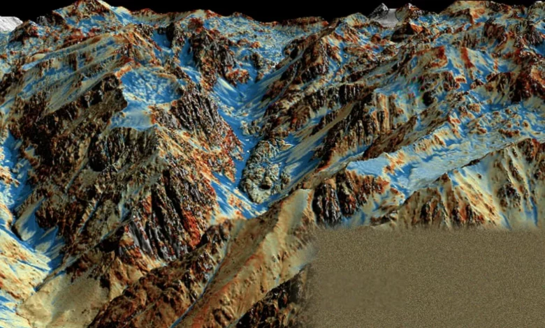
How Lidar is transforming snow measurement
The technology that is giving water managers an unblinking view of the crisis was developed by Painter while he was at Nasa’s Jet Propulsion Laboratory. His company, Airborne Snow Observatories, operates a specialised aircraft that flies above the Sierra Nevada and other ranges, firing rapid pulses of laser light at the ground below. The instrument, known as Lidar (Light Detection and Ranging), emits about 800,000 pulses per second. By measuring the time it takes for each pulse to bounce back, the system builds a three-dimensional map of the snow surface that is accurate to within three centimetres.
Because the aircraft can also fly the same routes after the snow has melted, it produces a bare-earth digital elevation model. Subtracting the snow-on measurement from the snow-off model gives the precise depth of the snowpack across an entire basin — a dramatic improvement over traditional methods. Historically, water managers have relied on SNOTEL (Snow Telemetry) sites: ground-based stations that provide point measurements at specific locations. These often miss the variation at higher elevations and across complex terrain. Lidar, combined with imaging spectrometers, also calculates the snow water equivalent (SWE) — the amount of liquid water stored in the snowpack — which is the critical number for forecasting how much water will eventually reach reservoirs, farms and taps.
The result is a data set that Painter likens to a survival guide for the parched American west. “The Lidar sprays out about 800,000 pulses per second,” he said. “The output is a 3D map of snow depth accurate to within 3cm.” With mountain ranges acting as “frozen reservoirs”, the technology gives state water officials the detailed intelligence they need to plan for the summer and autumn months.
Widespread drought and early melt
The data this year is sounding an alarm that extends far beyond California. According to the US Drought Monitor, more than 60% of the lower 48 states are now gripped by drought — the most widespread spring dry spell since the monitor began in 2000. Climate Central, an independent group of scientists and communicators, reported that the total water stored in the western snowpack this winter hit its lowest level on record precisely when it should have been at its annual peak. Multiple states — including Arizona, Colorado, Idaho, Nevada, New Mexico, Oregon, Utah and Wyoming — set new record-low April 1st SWE values. The Colorado River Basin experienced its warmest March on record.
A record-warm winter followed by a blistering March heatwave, both fuelled by heat-trapping pollution, decimated the snow cover. “In March the spigot shut off and it shut off across the entire western US,” Painter said. “Loss of snowpack like we’ve never seen. It’s not in the record at all. So this is unprecedented.” The peak SWE across western states occurred on average 21 to 34 days earlier than normal, and spring runoff from snowmelt is already flowing down mountainsides up to two months ahead of schedule.
Standing by a rushing stream outside Reno, Nevada, Tom Albright, the state’s deputy state climatologist, confirmed the pattern. “We wish we could tell it to stay put a little longer,” he said. The early melt creates a double danger. First, the landscape begins to dry out months ahead of time, priming it for wildfires. Second, major reservoirs that are already critically low will not be replenished. Lake Mead on the Colorado River is at 28% of capacity and Lake Powell at 23% as of early May, according to data from the US Bureau of Reclamation. “What happens when we don’t have the snowpack is we lose what water there was early and then we’re left with this really long dry season,” Albright said. When asked what concerned him most about the coming months, his answer was immediate: “Fire. Particularly because we have such a broad area that’s affected.”
The National Interagency Fire Center projects above-normal fire risk across much of the West. Already this year, more than 1.5 million acres have burned across the United States — more than double the ten-year average. The diminished snowpack also threatens agriculture, which consumes the bulk of the region’s water, and is disrupting riparian ecosystems and fish populations as stream flows dwindle.
A glimpse of the new normal
For decades, the water systems of the American west were built on the assumption that snow would linger in the mountains until the heat of mid-summer. The climate crisis is rewriting that playbook. While this year’s conditions are anomalous in the historical record, experts warn they are a preview of what is to come. “As we look forward, this year will become less and less unusual and may become not unusual at all at some point in the future,” Albright said. Warmer winters produce smaller snow reserves that melt earlier and must stretch longer into the summer, when water demand peaks. The technology Painter developed at Nasa — now being extended by the agency’s ICESat-2 mission, which uses Lidar to measure ice sheets and sea ice, with research into direct snow depth measurement drawing on concepts from ant colony behaviour — is giving water managers an increasingly precise view of the losses. But knowing the depth of the crisis does not make the water reappear.