UK Planning System and Housing Development Explained
Almost every debate about Britain’s housing shortage eventually arrives at the same word: planning. The planning system decides what can be built, where, and how quickly, and for decades it has been blamed in roughly equal measure for protecting the countryside and for strangling the supply of new homes. In 2026 it is also in the middle of its biggest overhaul in more than a decade, as a government committed to building 1.5 million homes rewrites the rules in an attempt to speed delivery up. This guide explains how the system actually works — who decides, what the stages are, why permission so often takes years rather than weeks — and what the current wave of reform is trying to change. It is written for the ordinary reader trying to understand why, in a country that agrees it needs more homes, building them remains so difficult.
What is the UK planning system?
The planning system is the legal framework that controls the development and use of land. In essence, it decides whether a proposed change — a new housing estate, an extension, a wind farm, a change from a shop to a flat — is allowed to go ahead, and on what terms. Its foundations were laid by the Town and Country Planning Act 1947, which nationalised the right to develop land: since then, with limited exceptions, you cannot build or materially change the use of land without permission from the state, regardless of who owns it. That principle, that development rights belong to the public even when the land is private, is the single most important thing to understand about how Britain plans.
England, Scotland, Wales and Northern Ireland each run their own planning systems, and this guide focuses on England, where the framework is set nationally but applied locally. National government sets the overall policy direction, most importantly through the National Planning Policy Framework, which all decisions must take into account. The day-to-day work, however, is done by local planning authorities — usually the planning department of a district, borough or unitary council — which prepare local plans, decide applications and enforce the rules in their area. In national parks the relevant national park authority takes on this role, and county councils handle minerals and waste.
The system is built to do two things that are often in tension: enable the development a growing country needs, and protect the things people value — green spaces, historic buildings, the character of established places, the environment. Almost every controversy in planning is a version of that tension playing out on a specific site. The reason the system feels slow and contested is not usually incompetence; it is that it is designed to weigh competing interests in public, case by case, and that process takes time. Planning sits at the heart of the wider UK housing market, because the rate at which land is released and permissioned is one of the fundamental constraints on how many homes ever get built.
Who decides what gets built?
Decisions about individual developments are made by the local planning authority, but the way they are made depends on the scale and sensitivity of the proposal. The great majority of applications — small extensions, minor works, uncontroversial schemes — are decided by professional planning officers under what are called delegated powers, without ever going before elected councillors. Only larger, more contentious or departure applications go to the authority’s planning committee, a group of elected councillors who vote on whether to approve, refuse or attach conditions. This division matters, because it is where much of the unpredictability in the system lives: an officer may recommend approval on planning grounds, only for a committee to refuse it in response to local opposition.
Crucially, planning decisions are not supposed to be a popularity contest. The law requires that applications be decided in accordance with the development plan — the local plan and any neighbourhood plans — unless material considerations indicate otherwise. A material consideration is a genuinely planning-related factor: the impact on traffic, on neighbours’ light and privacy, on heritage, on flood risk, on the character of an area. The number of objections is not, in itself, a material consideration; nor is the identity of the applicant, the effect on a neighbour’s property value, or competition with an existing business. This is why a scheme with hundreds of objectors can still be approved, and why “everyone is against it” is not, on its own, a reason a council can lawfully use to refuse.
Above the local authority sits the Planning Inspectorate, an executive agency that decides appeals on behalf of the Secretary of State when an applicant believes a refusal was wrong. The Secretary of State also has the power to “call in” applications of national significance and decide them directly, and to recover certain appeals. For the largest infrastructure projects — major energy, transport and water schemes classed as Nationally Significant Infrastructure Projects — a separate, centralised consenting regime applies, designed to keep nationally important development out of the standard local process.

How do local plans shape development?
The local plan is the foundation of the whole system, and yet it is the part the public understands least. Prepared by each local planning authority, a local plan sets out a vision for how an area will develop over roughly fifteen to twenty years: how many homes are needed, where they should go, which land is allocated for development and which is protected. Because applications must be decided in line with the plan, the most important decisions about where building happens are made not when an application is submitted, but years earlier, when the plan allocates the sites. By the time a controversial estate reaches the application stage, the principle of developing that land has often already been settled in the plan.
This is where one of the system’s deepest problems lies. Preparing a local plan is slow, expensive and politically painful, because it forces a council to identify, in public, exactly which fields and sites will be built on. As a result, plan-making has fallen badly behind: fewer than a third of local planning authorities in England have an up-to-date local plan. When a plan is absent or out of date, a different rule kicks in — the “presumption in favour of sustainable development”, which tilts decisions towards approval and makes it much harder for a council to refuse housing. Authorities without a current plan therefore lose control over where development goes, ending up with applications they did not choose rather than allocations they did.
The government’s response has been to try to force plans back up to date and standardise how housing need is calculated. Mandatory housing targets, removed by the previous government and restored in December 2024, require each authority to plan for a centrally calculated level of housing need rather than a number of its own choosing. Authorities are also held to account through the Housing Delivery Test and five-year housing land supply rules: where delivery falls short, penalties such as a 20 per cent buffer on the land an authority must identify apply from July 2026, and the presumption in favour of development bites harder. The logic is blunt — if councils will not plan for enough homes, the system is designed so that they lose the ability to say no.
What types of planning permission are there?
Not everything needs a full application, and understanding the different routes is the practical heart of the system. The most common is full planning permission, which requires detailed plans of exactly what is proposed — appearance, layout, materials, access — and which, once granted, lets the development proceed subject to any conditions. For larger or speculative schemes, outline planning permission establishes whether the principle of development is acceptable before an applicant spends money on detailed design; the details are then submitted later as a “reserved matters” application. Permission in principle is a newer, lighter route that confirms a site is acceptable for a given use, with technical details consented separately. Householder applications cover extensions and alterations to a single home.
A large amount of minor development does not need an application at all, because it is covered by permitted development rights — a national grant of permission for things like modest extensions, loft conversions and certain outbuildings, subject to limits on size and siting. Permitted development has been expanded over the years to include some changes of use, such as converting offices or shops into homes, a policy that has added housing supply but has been criticised for sometimes producing very poor-quality flats. Where there is doubt about whether a project needs permission, an owner can apply for a Lawful Development Certificate to confirm it in writing, which is well worth having when a home is later sold. The table below summarises the main routes.
| Type | What it does | Typical use |
|---|---|---|
| Full planning permission | Approves a fully detailed scheme | Most developments, from extensions to estates |
| Outline permission | Approves the principle; details follow as reserved matters | Larger or phased schemes, testing viability first |
| Reserved matters | Approves the details after an outline consent | Second stage of an outline scheme |
| Permission in principle | Confirms a site is acceptable for a use; technical details follow | Smaller residential sites in suitable locations |
| Householder application | Approves alterations to a single existing home | Extensions, conversions within a property |
| Permitted development | Pre-granted nationally; no application needed | Modest works, some changes of use |
How does the planning application process work?
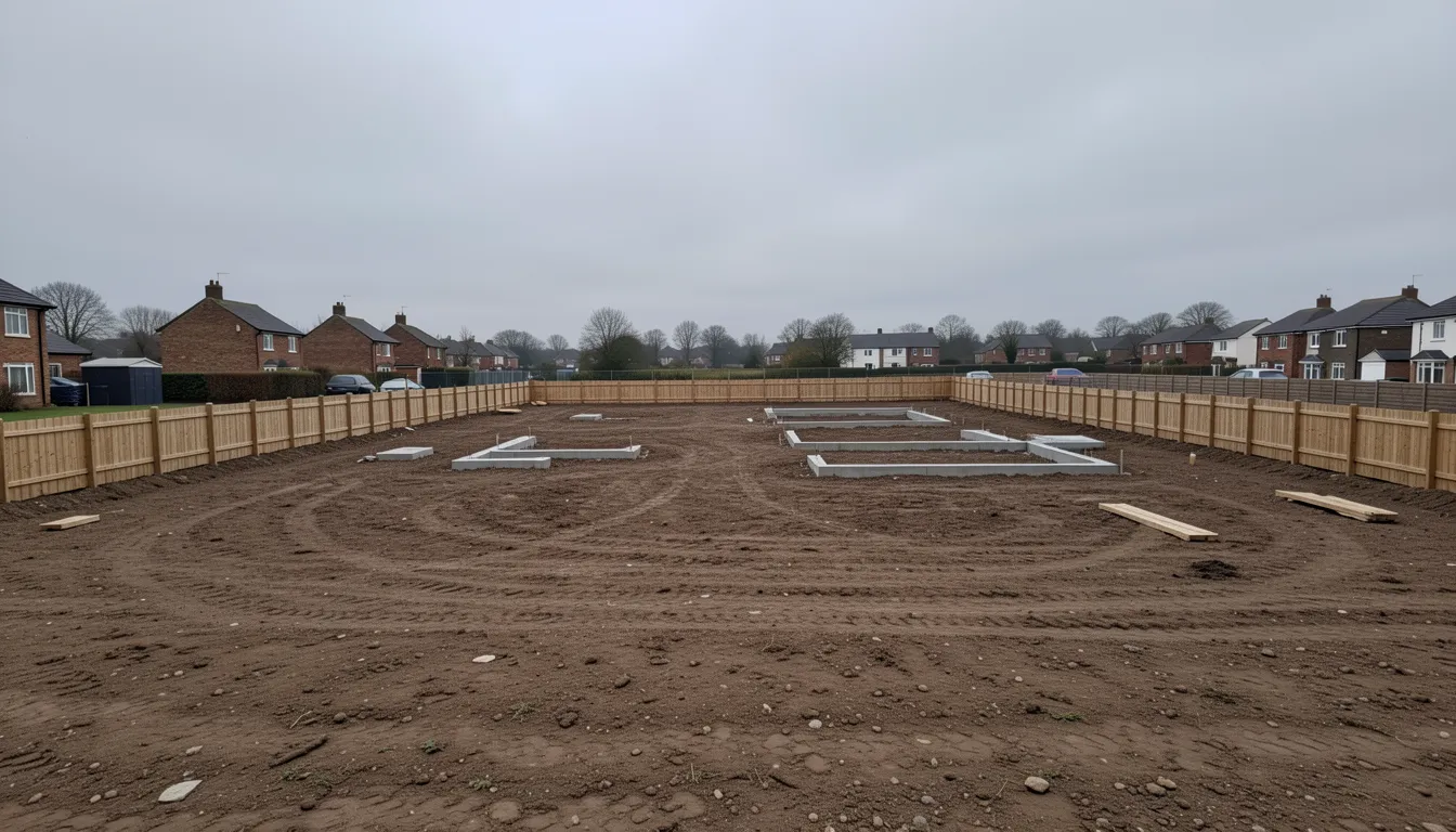
A planning application follows a recognisable sequence, though each stage can stretch in practice. Many applicants begin with pre-application advice, paying the council for an early view on whether a proposal is likely to succeed — money that can save far more if it reveals a fatal problem before detailed design. The formal application, submitted online through the Planning Portal, is first checked for completeness in a validation stage. Once validated, the authority publicises it: neighbours are notified, a site notice may go up, and statutory consultees such as the highways authority, the Environment Agency or heritage bodies are invited to comment, usually over a period of around 21 days.
A planning officer then assesses the proposal against the development plan and material considerations, visits the site, and writes a report recommending approval or refusal. For a delegated application the officer makes the decision; for a committee application the report goes to councillors to decide. The statutory targets for a decision are eight weeks for most minor applications, thirteen weeks for major development, and sixteen weeks where an Environmental Impact Assessment is required. These are targets, not guarantees: in practice, a great many decisions take longer, with authorities and applicants frequently agreeing extensions of time in writing, particularly on large or complex sites.
The decision itself takes one of three forms: approval, approval with conditions, or refusal. Conditions are extremely common and can require anything from submitting landscaping details to restricting working hours during construction. A full permission typically must be acted on within three years or it lapses. If an application is refused, or if the authority fails to decide it within the statutory period — known as non-determination — the applicant can appeal to the Planning Inspectorate, a process that can itself take anywhere from a few months to well over a year depending on whether it is handled by written representations, a hearing or a full inquiry. The cumulative effect of these stages, each reasonable on its own, is a process that routinely runs to many months even when nothing goes wrong.

What do developers have to contribute?
Permission to build is rarely granted for nothing. When a development goes ahead, the planning system extracts contributions to offset its impact and to capture some of the uplift in land value that permission creates. The two main mechanisms are Section 106 agreements and the Community Infrastructure Levy. A Section 106 agreement is a legal contract between the developer and the authority, tied to a specific site, that secures things like a proportion of affordable housing, a contribution to local schools or roads, or other site-specific mitigation. The Community Infrastructure Levy is a more standardised charge per square metre, set locally, that funds the broader infrastructure an area needs to support growth.
Affordable housing delivered through Section 106 is one of the most important, and most fragile, parts of the supply chain. Much of the affordable housing built in England comes not from direct government grant but from these agreements, delivered by private developers as a condition of building market homes, and it feeds into the wider stock of social and affordable housing. In 2024-25, an estimated 36 per cent of new affordable completions delivered through housing associations or local authorities came via Section 106 nil-grant agreements. The weakness of this model is that it is tied to the market: when private development slows, the affordable housing that piggybacks on it slows too, which is why affordable supply tends to fall exactly when need is rising.
These contributions are also where viability disputes arise. Developers can argue that the contributions demanded would make a scheme financially unviable, and negotiate them down — a process critics say is used to erode affordable housing commitments, and which defenders say is necessary to keep marginal sites moving. The tension between extracting public benefit and keeping development viable runs through every major scheme, and it is one reason the headline affordable housing figures attached to a planning permission are not always the numbers that get built. Whether the balance is struck well is ultimately a question of how UK government policy is made and enforced.
Why does the planning system slow housing down?
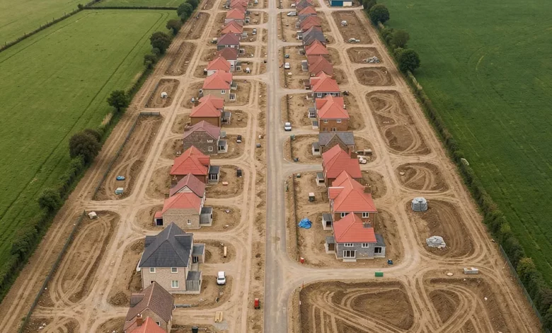
The charge that planning blocks housing is partly true and partly a useful political simplification, and it is worth separating the two. England is genuinely building fewer homes than it needs: there were 208,600 net additional dwellings in 2024-25, a 6 per cent fall on the year before and the third consecutive annual decline, against a target that implies around 300,000 a year. New build completions have drifted down to roughly 141,000 a year by late 2025. On any measure, supply is well short of both the government’s ambition and most estimates of need.
But planning delay is only one of several constraints, and not always the binding one. The system’s genuine drags are real: out-of-date local plans, under-resourced planning departments, slow decisions, lengthy appeals, and the uncertainty created when committees overturn officer recommendations. Securing permission on a large site, then discharging conditions and reserved matters, can take years before a single brick is laid. Yet permission is not the same as completion. Hundreds of thousands of homes have planning permission but remain unbuilt, because the pace at which developers build out a site — the “build-out rate” — is shaped by their commercial interest in not flooding a local market and depressing prices. The deeper constraint, many analysts argue, is demand: housebuilders build at the rate they can sell, so the number of homes completed is ultimately limited by how many buyers, at current prices and mortgage rates, can purchase them.
This distinction matters for judging whether reform will work. Forecasters are sceptical that the 1.5 million target is reachable: independent analysis suggests completions are more likely to settle around 160,000 to 170,000 a year even after the reforms, because the planning changes remove a barrier without guaranteeing the demand needed to fill the homes. In other words, faster planning is necessary but not sufficient. A system that grants more permissions more quickly will only translate into more homes if there are buyers and funded social landlords ready to take them on, which ties the fate of planning reform to interest rates, incomes and the broader health of the cost of living.
What is the Green Belt, and why is it so contested?
No part of the planning system generates more heat than the Green Belt, and much of the public debate about it rests on a misunderstanding of what it actually is. The Green Belt is not a designation for land of special natural beauty or ecological value; it is a planning tool, created to prevent urban sprawl by keeping defined rings of open land around major towns and cities permanently undeveloped. Its purposes are about shape and containment — stopping settlements from merging into one another and preserving a sense of separation — rather than protecting the most attractive countryside, much of which lies outside it. A scruffy field or a disused car park can be Green Belt; a stretch of genuinely beautiful but undesignated countryside may not be.
This distinction sits at the centre of the current reforms. The government has introduced the concept of “grey belt” — previously developed or low-quality land within the Green Belt that does not strongly serve its purposes — and made it easier to release for housing. Where Green Belt land is developed, “golden rules” require developers to provide a higher share of affordable housing and contributions to infrastructure, so that building on protected land delivers clear public benefit. Supporters argue this is a pragmatic way to unlock land near where people want to live without sacrificing the Green Belt’s core function; opponents see it as the thin end of a wedge that will erode a protection many regard as sacrosanct.
The Green Belt is only one of several land designations that constrain development, and a single site can carry more than one. Conservation areas protect the character of historic places; listed building status protects individual structures; National Parks and National Landscapes (formerly Areas of Outstanding Natural Beauty) protect valued landscapes; Sites of Special Scientific Interest protect habitats; and flood risk zones restrict building where water poses a danger. Each adds a layer of assessment to an application, and each reflects a genuine public interest. The art of the planning system — and the source of much of its slowness — is weighing these protections against the equally real need for homes, case by case, in public.
How is the planning system being reformed in 2026?
The current government has made planning reform central to its growth agenda, and 2026 is the year most of it takes effect. The centrepiece is the Planning and Infrastructure Act 2025, which received Royal Assent in December 2025. It streamlines the consenting process for major infrastructure, reforms how planning committees operate — reducing councillors’ ability to override officer recommendations on straightforward housing applications — and creates a Nature Restoration Fund, allowing developers to pay into a central fund to discharge certain environmental obligations at scale rather than site by site, administered by Natural England through Environmental Delivery Plans. Many of its provisions require secondary legislation, so they come into force in stages through 2026 and beyond.
Running alongside the Act is the most substantial rewrite of the National Planning Policy Framework since it was introduced in 2012. A draft published in December 2025, consulted on until March 2026, proposes a clearer, more rules-based framework with standardised National Decision-Making Policies to reduce inconsistency between authorities, a permanent presumption in favour of well-located development, a default “yes” to homes around railway stations, and stronger support for higher-density development and for small and medium sites. The reforms also continue an earlier shift on the Green Belt, allowing the release of lower-quality “grey belt” land subject to “golden rules” that require affordable housing and infrastructure contributions where Green Belt land is developed.
Underpinning all of this is an attempt to fix the system’s capacity, not just its rules. The government has committed funding to recruit around 1,400 additional planning officers over the Parliament, on the recognition — widely shared across the industry — that reform without resourcing will not deliver. Whether the package succeeds is the central open question of housing policy. Supporters argue it removes long-standing barriers and brings welcome consistency; critics, including some councils and environmental groups, warn that it centralises power, weakens local democratic control and risks trading environmental protection for speed. What is not in doubt is the scale of the ambition, or the gap between it and current delivery. Planning reform is one of the defining domestic stories running through UK news, and its outcome will shape the housing market for a generation.
How can the public get involved in planning?
For all its technical complexity, the planning system is one of the few areas of government where an ordinary person can directly influence a decision — but only if they engage on the system’s own terms. Anyone can comment on a planning application during its consultation period, and anyone can take part in the consultation on a local plan, which is in many ways the more consequential moment because it shapes years of future development. Applications and plans are published on each council’s planning portal, where comments can be submitted online.
The practical lesson, often learned too late by objectors, is that comments only carry weight when they raise material planning considerations. An objection that a development will overshadow neighbouring homes, generate unsafe traffic, harm a listed building or flood a road speaks the language the system recognises. An objection that simply says residents do not want it, that it will reduce house prices, or that the area is “already busy enough” carries little or no weight, however many people sign it. Engaging early — at the local plan stage, and through a neighbourhood plan where one exists — and framing concerns in planning terms is far more effective than mass objection to an application whose principle was settled years before.
It is worth being honest that the reforms now under way are designed, in part, to reduce the ability of local opposition to block housing, by strengthening national policy and curbing the discretion of planning committees. For people who want more homes built, that is the point; for those who value local control, it is the concern. Either way, the route to influence is the same: understand what the system treats as relevant, engage at the plan-making stage rather than waiting for an application, and make the case in terms a planner can lawfully act on.
UK Planning System: Frequently Asked Questions
Do I need planning permission to build or extend?
You generally need planning permission to build something new, make major alterations or extensions, or change the use of a building or land. Many smaller works — modest extensions, loft conversions and some outbuildings — are covered by permitted development rights and need no application. If you are unsure, check with your local planning authority or apply for a Lawful Development Certificate, which confirms in writing that your project is lawful and is useful when you later sell the property.
How long does planning permission take?
The statutory targets are eight weeks for most minor applications, thirteen weeks for major development, and sixteen weeks where an Environmental Impact Assessment is required. These are targets rather than guarantees, and many decisions take longer, with the council and applicant often agreeing an extension of time in writing, particularly on large or complex sites.
Who decides planning applications?
Most applications are decided by professional planning officers under delegated powers, without going to councillors. Larger, more contentious or departure applications go to the local planning authority's planning committee, made up of elected councillors. Appeals against refusals are decided by the Planning Inspectorate on behalf of the Secretary of State, who can also call in significant applications to decide directly.
Can local objections stop a development?
Comments only carry weight when they raise material planning considerations — things like the impact on traffic, neighbours' light and privacy, heritage, flood risk or the character of an area. The number of objections, the effect on property values, and simply not wanting a development are not material considerations and carry little weight. Engaging early, at the local plan stage, is more effective than objecting to an application whose principle was settled years before.
What is the difference between Green Belt and grey belt?
The Green Belt is a planning tool that keeps rings of open land around towns and cities undeveloped to prevent urban sprawl and stop settlements merging — it is about containment, not protecting the most beautiful countryside. 'Grey belt' is a newer category of previously developed or low-quality Green Belt land that the government has made easier to release for housing, subject to 'golden rules' requiring affordable housing and infrastructure contributions.
What are Section 106 agreements and the Community Infrastructure Levy?
Section 106 agreements are site-specific legal contracts securing things like affordable housing or contributions to local schools and roads. The Community Infrastructure Levy is a more standardised per-square-metre charge funding wider infrastructure. Together they offset a development's impact and capture some of the land value that permission creates, and they are a major source of the affordable housing built in England.
Related guides
- How the UK Housing Market Works
- Renting in the UK: Tenant Rights and Landlord Obligations
- How UK Government Policy Is Made