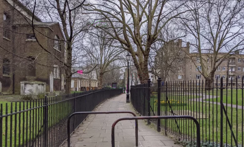
A narrow, fenced passage in Paddington, separating a historic church from a public garden, stands as a silent witness to centuries of urban change—from medieval chapel and Georgian burial disputes to the brutal incursion of 1960s motorways.
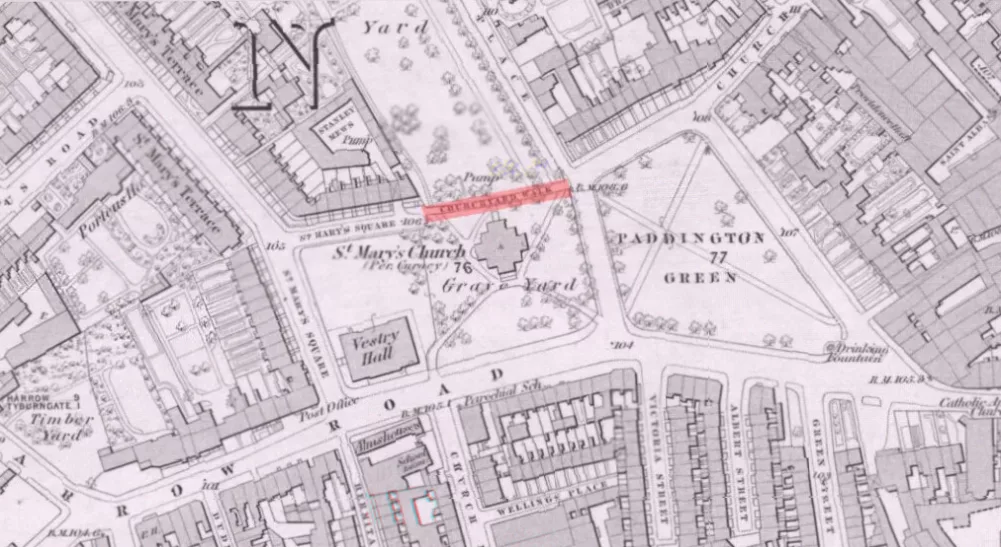
Church Yard Walk, as the path is now signed, is a fragment of a much older thoroughfare. Cartographic evidence reveals its long evolution. John Rocque’s meticulous map of London, surveyed between 1737 and 1746, shows what appears to be a wide road just north of the site of the current St Mary on Paddington Green Church. This route was later blocked off, but a pedestrian right of way was retained, visible as a small dotted line on Christopher and John Greenwood’s detailed map of 1828.
A Church of Ancient Foundation and Georgian Elegance
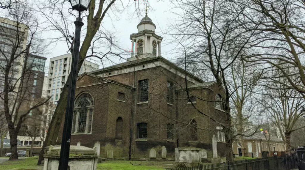
The passage’s story is inextricably linked to the church it borders. St Mary on Paddington Green has ancient origins, with the earliest documentation of a chapel at Paddington dating to 1222. Originally a chapel dedicated to St Catherine, it was rebuilt as a parish church dedicated to St James in 1678. The present building, the third on the site, was consecrated to St Mary in 1791.
Designed by architect John Plaw, the current church is a Grade II* listed Georgian structure, notable for its Greek cross plan and compact design. It is considered Plaw’s only surviving building in London.
Graveyard Expansions and a Costly Dispute
As London grew, so did the need for burial space. The church’s graveyard expanded northwards in stages: in 1732, 1753, 1788, 1810, and finally in 1825. It was during these expansions that the old road shown on Rocque’s map was closed to create a single site for the church and its graveyard.
Burials were, however, a significant source of income for parishes, and a major dispute arose in 1796. The Bishop of London claimed half the income from burials at Paddington. The assistant curate rebuffed the demand and was subsequently sacked. In response, burials of non-parishioners were banned until payments resumed—a serious financial blow at a time when such fees could add £250 a year to a church’s income.
The Bishop of London piled on the pressure by refusing to consecrate the larger burial ground until the matter was resolved. The conflict highlights the often-contentious financial realities of parish management in the 18th century.
Burials in the ground finally ceased in 1857. After years of neglect, much of the former graveyard was repurposed as a public recreation space, with St Mary’s Gardens being laid out in the 1890s.
An Early Example of Pedestrian Priority
The survival of Church Yard Walk as a dedicated path represents an early, informal example of pedestrianisation in London. While the modern concept of permanent pedestrian zones is more recent, the practice of restricting vehicle access has historical roots.
Other early London streets with pedestrian priority include Woburn Walk, Cosmo Place, and Cecil Court. Significant formal schemes came later, such as the part-time pedestrianisation of Carnaby Street in 1973 and the transformation of the north side of Trafalgar Square in 2003. Notably, London Street in Norwich became the first existing UK shopping street to be pedestrianised in 1967.
The Motorway Era and a Communal Grave
The tranquil setting was violently disrupted in the 1960s by the demands of the car. The construction of the Marylebone Flyover, which opened in 1967, and the A40 Westway elevated dual carriageway, built between 1962 and 1970, sliced through the southern half of the church grounds.
The impact was profound. In 1966, over 450 graves from the southern part of the churchyard were exhumed to make way for the new roads. The exhumed remains were reinterred in a communal grave at Paddington New Cemetery, now known as Mill Hill Cemetery.
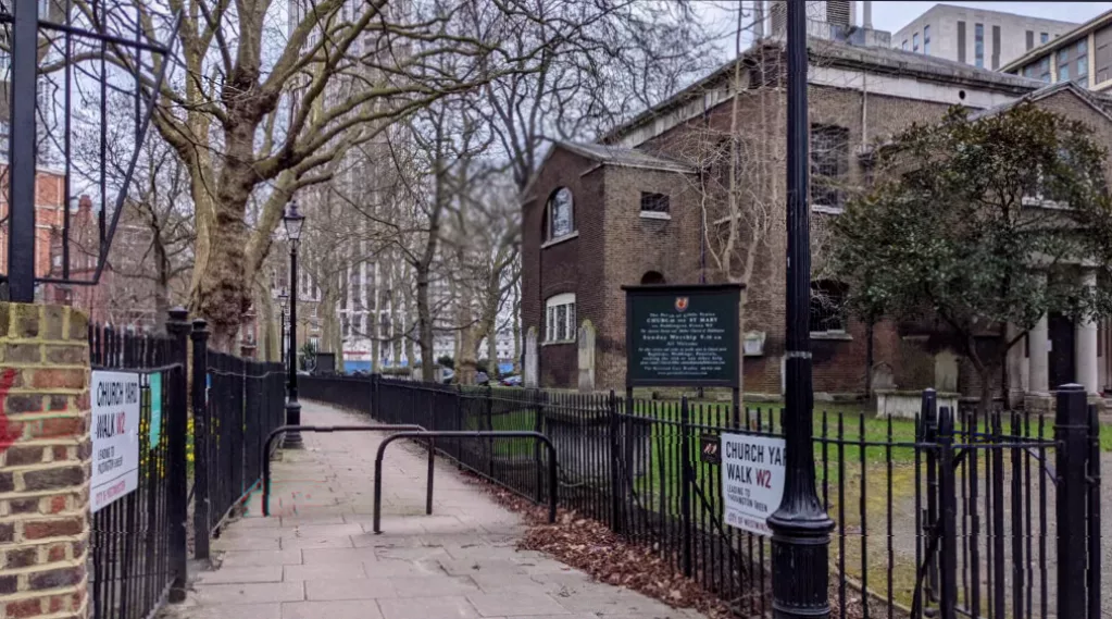
The compensation offered to the church for this land funded restoration work on the church and its remaining grounds. While the iron railings along Church Yard Walk have an olde-worlde charm, they likely date from this period of 1960s refurbishment, rather than being original.
These projects were part of London’s first urban motorway scheme, criticised for their environmental impact and disruption to communities, and they irrevocably altered the Paddington area, which had already been transformed in the 19th century by the arrival of the Grand Junction Canal, the Great Western Railway, and omnibus routes.
Today, only a subtle quirk in the street sign hints at the layers of history beneath one’s feet: for most of its history, the path was known as ‘Churchyard Walk’, but the modern sign reads ‘Church Yard Walk’.